IN-DEPTH / IN-DEPTH
Uncovering why Nansha Qundao belongs to China through archaeological relics, historical maps
Facts speak louder

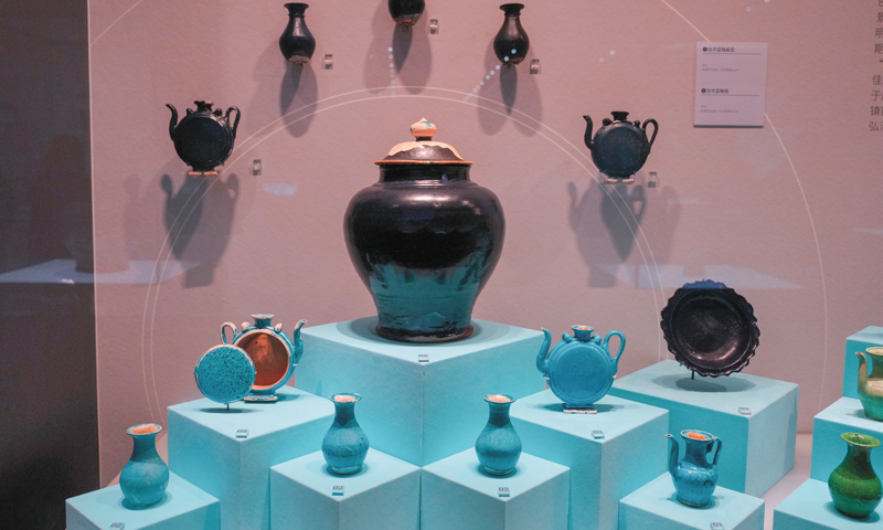
Exhibits from an archaeological achievement exhibition on South China Sea shipwrecks at the China (Hainan) Museum of the South China Sea in Qionghai, Hainan, on September 29, 2024 Photo: VCG
Editor's Note:
The activities of the Chinese people in the South China Sea date back over 2,000 years. China is the first to have discovered, named, explored, and utilized the maritime resources on and around Nansha Qundao and relevant waters, and the first to have continuously, peacefully, and effectively exercised sovereignty and jurisdiction over them. Silent archaeological relics are faithful witnesses to this.
The Global Times is launching the series "Artifacts Tell South China Sea Truth." Through historical relics, maps, and other materials from ancient and modern times, both at home and abroad, the evidences will show how China's territorial sovereignty and maritime rights and interests in the South China Sea have long been clearly recorded and recognized by world history. This is the first installment in the series, focusing on what historical relics, archaeological documents, and literature support the legitimacy of China's sovereignty over Nansha Qundao.
Since ancient times, some waters in the South China Sea have been full of navigation risks due to the presence of numerous reefs and hidden shoals. However, this has not stopped the hardworking and brave Chinese people from exploring in the South China Sea.
Based on archaeological discoveries, as far back as the Han Dynasty (202 BC-AD 220) and the Three Kingdoms period (220-280), the Chinese people had already carried out large-scale navigation activities in the South China Sea.
The activities of the Chinese people in the South China Sea have left numerous historical marks. These marks not only exist in documentary records but are also embodied in the cultural relics sleeping on the seabed or buried in the reefs, serving as the most direct manifestation of "historical footprints."
Historical footprints affirm China's steps
A historical book from the state of Wu during the Three Kingdoms period titled "Nanzhou Yiwu Zhi" (Records of Strange Things from the Southern Regions) shows that some areas in the South China Sea have shallow water and a large number of magnets. Large ships sailing in these areas, whose hulls were reinforced with iron sheets would be attracted by the magnets and run aground.
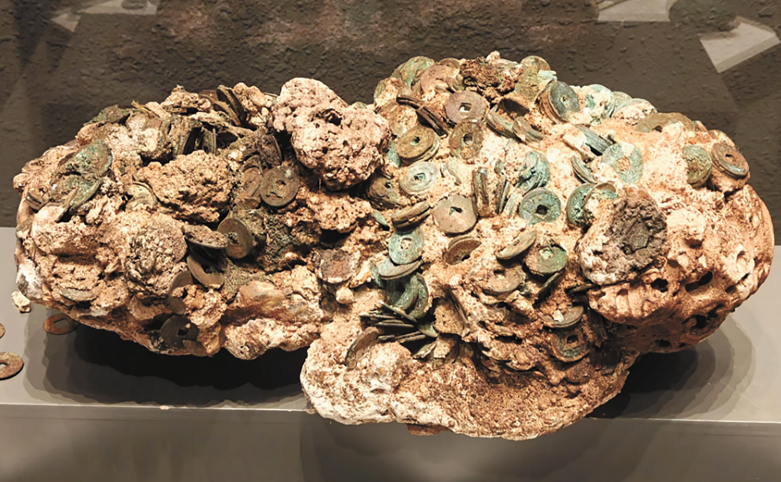
Obviously, not all ships in distress can escape danger. Many ships sank to the bottom of the sea without a trace. According to "textual research on the age required for coral reef growth" published by geologist Ma Tingying in "Bulletin of the Geological Society of China" in 1937, Chinese archaeologists discovered a large number of ancient coins wrapped in coral on the coral reefs of Xisha Qundao in 1920, including coins from the late Western Han Dynasty (202 BC-25 AD). These ancient coins saw the light of day again after nearly 2,000 years.

People visit the China (Hainan) Museum of the South China Sea in Qionghai, South China's Hainan Province, on February 5, 2025. Photo: IC
Later, during the Tang and Song dynasties (618-1279), the Chinese people's navigation and fishing activities in the South China Sea became more frequent, and even lived on the South China Sea islands for a long time.
According to public reports, from 1974 to 1975, Chinese archaeologists excavated the Tang and Song residential sites on Ganquan Dao in Xisha Qundao. They unearthed porcelain, ironware, and copper ornaments, among other artifacts, which are believed to be daily production and living utensils used by fishermen on the island at the time, and are the same as similar utensils in the coastal areas of South China's Guangdong and East China's Fujian provinces during the Tang and Song dynasties.
With the deepening of archaeological excavations, tens of thousands of cultural relics have begun to appear before the world. They are of various types, including ceramics, iron bars, bronze mirrors, and copper coins, to name a few. Among them, the number of ceramics is particularly large. Nearly 10,000 pieces of porcelain cover various types such as blue-white glaze, celadon glaze, white glaze, and dark brown glaze. Most of these pieces of porcelain are blue-white porcelain, which are beautifully shaped and have a warm glaze color. They were common porcelain varieties during the Song Dynasty (960-1279) and Yuan Dynasty (1271-1368), and were mainly produced by folk kilns in southern Fujian in the Song Dynasty period, according to the China Institute for Marine Affairs (CIMA) under China's Ministry of Natural Resources.
During the Ming and Qing dynasties (1644-1911), maritime navigation in the South China Sea flourished, and along with it, production, living, and development activities on various reefs and islands in the South China Sea increased and deepened. The archaeological discovery of a large number of cultural relic sites from the Ming and Qing dynasties further proves that the South China Sea islands and their relevant waters have long been a homeland operated and developed by the Chinese people.
According to information provided by the CIMA, since the Republic of China (1912-1949), Chinese archaeologists have discovered a total of about 140,000 copper coins in Xisha Qundao. Among these copper coins, the "Yongle Tongbao" coins officially cast during the Yongle period of the Ming Dynasty accounted for half of the total, with more than 70,000 pieces. These copper coins are all new and unused, maintaining their original state of being strung together and neatly stacked.
Archaeologists have speculated that these "Yongle Tongbao" were most likely newly minted coins taken from official warehouses during the renowned Chinese navigator and explorer Zheng He's voyages to the West. When his fleet sailed to the waters near Beijiao Jiao of Xisha Qundao, it unfortunately sank, causing these copper coins to be deposited at the bottom of the sea.
In addition to coins, in the spring of 1974 and from March to April 1975, archaeological experts from Guangdong Province excavated a total of 14 small temples from the Ming and Qing dynasties in the Xuande Qundao area, including Yongxing Dao, and some Yongle Qundao reefs in Xisha Qundao, according to the CIMA.
The "Yongle Tongbao" coins in the Yongle period of the Ming Dynasty found in the South China Sea Photo: Courtesy of China Institute for Marine Affairs under China's Ministry of Natural Resources
In addition, in some temple sites, archaeologists have successively unearthed relics such as Buddha statues, sacrificial utensils, and ancestral tablets, according to media reports.
Chen Xidi, an expert at the China Institute for Marine Affairs at the Ministry of Natural Resources, told the Global Times that these precious historical relics discovered in archaeological findings in the South China Sea have confirmed that China has indisputable historical sovereignty, sovereign rights, and jurisdiction over the South China Sea islands and adjacent waters.
Maps tell the fact
As an important carrier of geographical information, maps also clearly record China's jurisdiction over Nansha Qundao, including Huangyan Dao. From ancient navigation guides to modern official annotations, maps tell the historical fact of China's continuous jurisdiction over this region.
The "Genglu Bu" (Navigation Route Book), a navigation manual used by Hainan fishermen since the Ming Dynasty, records five routes to Huangyan Dao, reflecting the historical facts of Hainan fishermen's navigation and production here, Chen revealed.
"Genglu Bu" is a summary of the navigation experience and a crystallization of the collective wisdom of fishermen in the South China Seafor thousands of years. It details navigation knowledge such as navigation routes, reef and island names, and ocean currents in the South China Sea, including more than 100 place names and important marine information. This navigation manual not only helps fishermen sail safely in the vast South China Sea, but also serves as an important guide for their fishing, shipping, and other production activities, the scholar introduced.
At the same time, "Genglu Bu" also records natural information such as landforms, sea conditions, tides, and storms in the South China Sea, which is of precious historical value for people to study and develop the South China Sea today, Chen noted.
In "Genglu Bu," fishermen also confirmed the orientation and named the reefs and islands of the Nansha Qundao. Behind the names of reefs and islands in "Genglu Bu" is the deep connection between fishermen and the South China Sea islands, and it has also become an important basis for the Chinese government to name the reefs and islands in the South China Sea, the scholar said.
In June 2008, "Genglu Bu" was included in the second batch of the national intangible cultural heritage list with the approval of the State Council, which further proved its important status.
In the current South China Sea situation that has become increasingly complicated due to interference and instigation by some countries, "Genglu Bu" is like a beacon across space and time, illuminating the historical corridor. With its irrefutable historical facts, it demonstrates the profound historical foundation of China's sovereignty and maritime rights and interests over the South China Sea islands, including the Nansha Islands, Chen stressed.
Archaeological discoveries in the South China Sea not only reveal the living conditions and economic activities of residents on the South China Sea islands since ancient times, but also constitute strong evidence that China is the true owner of the South China Sea islands, and clear proof of China's historical rights in the South China Sea.
China's territorial sovereignty and maritime rights and interests in the Nansha Islands are beyond doubt, with countless historical materials serving as silent yet firm witnesses.
Facts speak louder
No comments:
Post a Comment