Tuesday, September 30, 2025
Friday, September 26, 2025
Thursday, September 25, 2025
Monday, September 22, 2025
GT: Ironclad historical evidence reveals Philippines claim over Huangyan Dao a gtoundless farce. 21st Feb, 2024
IN-DEPTH / IN-DEPTH
Ironclad historical evidence reveals Philippines' claim over Huangyan Dao a groundless farce
Maritime malcontents


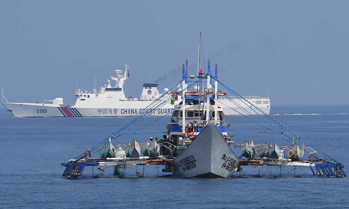
China Coast Guard expels Philippine vessel for illegal intrusion into South China Sea waters after repeated warnings on February 15, 2024. Photo: Visual News
Editor's Note:
Over the last two weeks, while the Chinese people were celebrating the Spring Festival holidays, several Philippine vessels illegally intruded into the waters adjacent to China's Huangyan Dao, also known as Huangyan Island. Despite repeated warnings from the China Coast Guard (CCG), the Philippine vessel persisted in its activity. The CCG had to implement measures to control the vessel's navigation and compel it to leave the area in accordance with the law.
Since the 1990s, Chinese fishermen fishing in the waters near Huangyan Dao have frequently been harassed by the Philippine military. After the Marcos administration came to power in 2022, incidents of Philippine vessels intruding into the waters near Chinese islands and reefs have increased in frequency.
China was the first country in history to start and continue to manage South China Sea islands and engage in related maritime activities. Successive Chinese governments in all dynasties have continuously and peacefully had jurisdiction over the South China Sea islands. Through collections from historical materials, evidence, and interviews with marine experts, the Global Times is publishing a series of stories to illustrate how the Philippines disregards historical fact, distorts international law, and violates the consensus, which was reached and repeatedly confirmed through negotiations between China and the Philippines. This is the first installment in the series, illustrating why China indisputably holds sovereignty over Huangyan Dao and its adjacent waters. In the second installment, we will illustrate why Ren'ai Jiao, also known as Ren'ai Reef, has always been Chinese territory and is an integral part of China's Nansha Islands geographically, economically, politically, and historically.
Solid historical proof
Huangyan Dao, which is located at 15°07'N, 117°51'E, is formed of coral reefs and is the only island exposed above the water among the Zhongsha Islands. It was recorded in the biography of astronomer Guo Shoujing in Yuan Shi (the History of the Yuan Dynasty) when Guo was commissioned by the Emperor to perform a land and sea survey in 1279. This confirms the discovery of Huangyan Dao by China as early as during the Yuan Dynasty (1279-1368).
Records show that Huangyan Dao is an inherent territory of China, and China continues to exercise sovereignty and jurisdiction over it in a peaceful, and effective manner. In January 1935, the Lands and Waters Mapping Review Committee of the then-Chinese government approved and published the names of 132 islands, shoals, reefs, and sand bars in the South China Sea. Huangyan Dao was registered under the name of Scarborough Reef, belonging to the Zhongsha Islands.
In October 1947, the then-Chinese government reviewed and published a list of name changes to the islands in the South China Sea, in which the name Scarborough Reef was replaced by Minzhu Jiao, still as part of the Zhongsha Islands. In 1983, in a published list of names of the South China Sea islands issued by Chinese national geographical names authority, the island was referred to as Huangyan Dao, with Minzhu Jiao as an alternative name.
The official maps published by the successive governments of China have always marked Huangyan Dao as Chinese territory. Huangyan Dao has been continuously under the jurisdiction of Guangdong Province and Hainan Province. Subsequent Chinese government's announcements and declarations regarding the sovereignty of the South China Sea islands have all stated that the Huangyan Dao belongs to China.
Since ancient times, Chinese fishing boats have frequently engaged in fishing activities in the waters around Huangyan Dao. The navigation manual used by Chinese fishermen in the South China Sea fully reflects the footsteps of South China Sea fishermen in the Xisha Islands, Nansha Islands, Zhongsha Islands, and other waters.
The Chinese governments had also sent research teams to Huangyan Dao multiple times for scientific exploration. This includes in October 1977, when a research group from the South China Sea Institute of Oceanology of the Chinese Academy of Sciences conducted investigations on the island. In June 1978, researchers from the same institute visited the island again for research purposes. In April 1985, the South China Sea Branch of the State Oceanic Administration organized a comprehensive survey on Huangyan Dao. In 1994, Chinese scientific expedition team arrived at Huangyan Dao for exploration and erected a one-meter-high cement monument on the island.
On the other hand, prior to 1997, the Philippines had never made territorial claims over Huangyan Dao. Huangyan Dao is not within the territorial range of the Philippines and is not Philippine territory. However, in April 1997, the Philippines changed its stance, claiming that Huangyan Dao is within the Philippines' claimed 200-nautical-mile exclusive economic zone, and therefore is "Philippine territory."
On February 17, 2009, the Philippine Congress passed an act, which unilaterally included Huangyan Dao and some Nansha Islands as Philippine territory. On April 11, 2012, a set of photographs which showed a group of Chinese fishermen standing shirtless, on the deck of a boat under the blazing sun grabbed news headlines. They were being held by Philippine Navy soldiers. It transpired that 12 Chinese fishing boats had been undertaking their regular fishing activities inside the Huangyan Dao territory, when on April 10, 2012, a Philippine naval vessel approached, harassed, and disrupted the fishing operations.
China has repeatedly lodged solemn representations against Philippine impingement on China's territorial sovereignty and harming Chinese fishermen. At the same time, the Chinese government swiftly took action to safeguard sovereignty and rescue the Chinese fishermen. In June 2012, the Philippines withdrew relevant vessels and personnel from Huangyan Dao.
Experts noted that the Philippines' assertion is a deliberate and absurd distortion of international law. The UN Convention on the Law of the Sea (Convention) allows coastal states to establish a 200-nautical-mile exclusive economic zone, but coastal states do not have the right to infringe upon the inherent territorial sovereignty of other countries. The practice of using the Convention to change the ownership of territorial sovereignty is a violation of international law, and negates the purposes and principles of the Convention.
Chinese Coast Guard vessels (rear) patrol the waters near Huangyan Dao in the South China Sea, on September 20, 2023. Photo: Visual News
Keep calling for peace
In 2016, China released a white paper titled "China adheres to the position of settling through negotiation the relevant disputes between China and the Philippines in the South China Sea." The white paper stated that while firmly safeguarding its territorial sovereignty and maritime rights and interests, China adheres to the position of settling disputes through negotiation and consultation, and managing differences through rules and mechanisms.
On July 14, 2023, when attending the series of foreign ministers' meetings on East Asia cooperation in Jakarta, capital of Indonesia, Director of the Office of the Central Commission for Foreign Affairs Wang Yi said that China has always insisted that disputes should be settled peacefully by the parties directly concerned through friendly consultation. This principle has also been included in the Declaration on the Conduct of Parties in the South China Sea (DOC).
Chen Hong, Asia-Pacific research expert at the East China Normal University, told the Global Times that in the near future, the Philippines will likely use the ASEAN, especially claimant countries, to distort and magnify territorial disputes into collective contradictions between China and the ASEAN, an approach obviously lacking in logic.
However, the Philippines has always been on the wrong, and the government's practice of misleading the public will not last long. China should let the power of peace receive more attention, Chen said.
GT: Uncovering why Nansha Qundao belongs to China through archaeological relics, historical maps. 15th Sept 2025
IN-DEPTH / IN-DEPTH
Uncovering why Nansha Qundao belongs to China through archaeological relics, historical maps
Facts speak louder

Exhibits from an archaeological achievement exhibition on South China Sea shipwrecks at the China (Hainan) Museum of the South China Sea in Qionghai, Hainan, on September 29, 2024 Photo: VCG
Editor's Note:
The activities of the Chinese people in the South China Sea date back over 2,000 years. China is the first to have discovered, named, explored, and utilized the maritime resources on and around Nansha Qundao and relevant waters, and the first to have continuously, peacefully, and effectively exercised sovereignty and jurisdiction over them. Silent archaeological relics are faithful witnesses to this.
The Global Times is launching the series "Artifacts Tell South China Sea Truth." Through historical relics, maps, and other materials from ancient and modern times, both at home and abroad, the evidences will show how China's territorial sovereignty and maritime rights and interests in the South China Sea have long been clearly recorded and recognized by world history. This is the first installment in the series, focusing on what historical relics, archaeological documents, and literature support the legitimacy of China's sovereignty over Nansha Qundao.
Since ancient times, some waters in the South China Sea have been full of navigation risks due to the presence of numerous reefs and hidden shoals. However, this has not stopped the hardworking and brave Chinese people from exploring in the South China Sea.
Based on archaeological discoveries, as far back as the Han Dynasty (202 BC-AD 220) and the Three Kingdoms period (220-280), the Chinese people had already carried out large-scale navigation activities in the South China Sea.
The activities of the Chinese people in the South China Sea have left numerous historical marks. These marks not only exist in documentary records but are also embodied in the cultural relics sleeping on the seabed or buried in the reefs, serving as the most direct manifestation of "historical footprints."
Historical footprints affirm China's steps
A historical book from the state of Wu during the Three Kingdoms period titled "Nanzhou Yiwu Zhi" (Records of Strange Things from the Southern Regions) shows that some areas in the South China Sea have shallow water and a large number of magnets. Large ships sailing in these areas, whose hulls were reinforced with iron sheets would be attracted by the magnets and run aground.
Obviously, not all ships in distress can escape danger. Many ships sank to the bottom of the sea without a trace. According to "textual research on the age required for coral reef growth" published by geologist Ma Tingying in "Bulletin of the Geological Society of China" in 1937, Chinese archaeologists discovered a large number of ancient coins wrapped in coral on the coral reefs of Xisha Qundao in 1920, including coins from the late Western Han Dynasty (202 BC-25 AD). These ancient coins saw the light of day again after nearly 2,000 years.

People visit the China (Hainan) Museum of the South China Sea in Qionghai, South China's Hainan Province, on February 5, 2025. Photo: IC
Later, during the Tang and Song dynasties (618-1279), the Chinese people's navigation and fishing activities in the South China Sea became more frequent, and even lived on the South China Sea islands for a long time.
According to public reports, from 1974 to 1975, Chinese archaeologists excavated the Tang and Song residential sites on Ganquan Dao in Xisha Qundao. They unearthed porcelain, ironware, and copper ornaments, among other artifacts, which are believed to be daily production and living utensils used by fishermen on the island at the time, and are the same as similar utensils in the coastal areas of South China's Guangdong and East China's Fujian provinces during the Tang and Song dynasties.
With the deepening of archaeological excavations, tens of thousands of cultural relics have begun to appear before the world. They are of various types, including ceramics, iron bars, bronze mirrors, and copper coins, to name a few. Among them, the number of ceramics is particularly large. Nearly 10,000 pieces of porcelain cover various types such as blue-white glaze, celadon glaze, white glaze, and dark brown glaze. Most of these pieces of porcelain are blue-white porcelain, which are beautifully shaped and have a warm glaze color. They were common porcelain varieties during the Song Dynasty (960-1279) and Yuan Dynasty (1271-1368), and were mainly produced by folk kilns in southern Fujian in the Song Dynasty period, according to the China Institute for Marine Affairs (CIMA) under China's Ministry of Natural Resources.
During the Ming and Qing dynasties (1644-1911), maritime navigation in the South China Sea flourished, and along with it, production, living, and development activities on various reefs and islands in the South China Sea increased and deepened. The archaeological discovery of a large number of cultural relic sites from the Ming and Qing dynasties further proves that the South China Sea islands and their relevant waters have long been a homeland operated and developed by the Chinese people.
According to information provided by the CIMA, since the Republic of China (1912-1949), Chinese archaeologists have discovered a total of about 140,000 copper coins in Xisha Qundao. Among these copper coins, the "Yongle Tongbao" coins officially cast during the Yongle period of the Ming Dynasty accounted for half of the total, with more than 70,000 pieces. These copper coins are all new and unused, maintaining their original state of being strung together and neatly stacked.
Archaeologists have speculated that these "Yongle Tongbao" were most likely newly minted coins taken from official warehouses during the renowned Chinese navigator and explorer Zheng He's voyages to the West. When his fleet sailed to the waters near Beijiao Jiao of Xisha Qundao, it unfortunately sank, causing these copper coins to be deposited at the bottom of the sea.
In addition to coins, in the spring of 1974 and from March to April 1975, archaeological experts from Guangdong Province excavated a total of 14 small temples from the Ming and Qing dynasties in the Xuande Qundao area, including Yongxing Dao, and some Yongle Qundao reefs in Xisha Qundao, according to the CIMA.
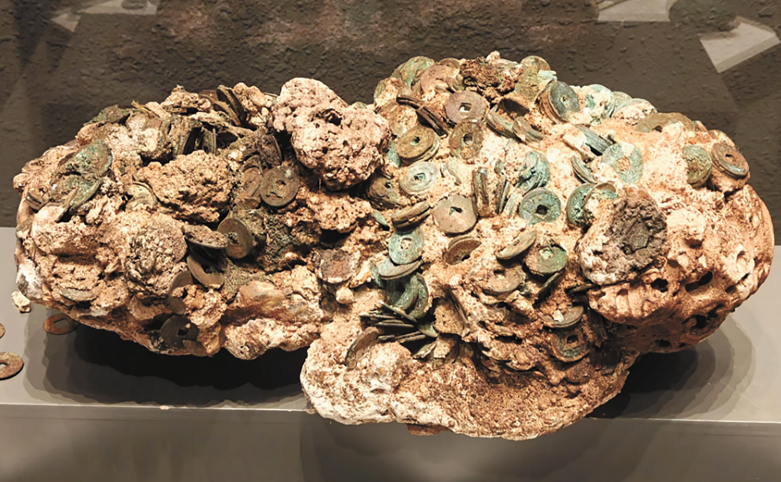
The "Yongle Tongbao" coins in the Yongle period of the Ming Dynasty found in the South China Sea Photo: Courtesy of China Institute for Marine Affairs under China's Ministry of Natural Resources
In addition, in some temple sites, archaeologists have successively unearthed relics such as Buddha statues, sacrificial utensils, and ancestral tablets, according to media reports.
Chen Xidi, an expert at the China Institute for Marine Affairs at the Ministry of Natural Resources, told the Global Times that these precious historical relics discovered in archaeological findings in the South China Sea have confirmed that China has indisputable historical sovereignty, sovereign rights, and jurisdiction over the South China Sea islands and adjacent waters.
Maps tell the fact
As an important carrier of geographical information, maps also clearly record China's jurisdiction over Nansha Qundao, including Huangyan Dao. From ancient navigation guides to modern official annotations, maps tell the historical fact of China's continuous jurisdiction over this region.
The "Genglu Bu" (Navigation Route Book), a navigation manual used by Hainan fishermen since the Ming Dynasty, records five routes to Huangyan Dao, reflecting the historical facts of Hainan fishermen's navigation and production here, Chen revealed.
"Genglu Bu" is a summary of the navigation experience and a crystallization of the collective wisdom of fishermen in the South China Seafor thousands of years. It details navigation knowledge such as navigation routes, reef and island names, and ocean currents in the South China Sea, including more than 100 place names and important marine information. This navigation manual not only helps fishermen sail safely in the vast South China Sea, but also serves as an important guide for their fishing, shipping, and other production activities, the scholar introduced.
At the same time, "Genglu Bu" also records natural information such as landforms, sea conditions, tides, and storms in the South China Sea, which is of precious historical value for people to study and develop the South China Sea today, Chen noted.
In "Genglu Bu," fishermen also confirmed the orientation and named the reefs and islands of the Nansha Qundao. Behind the names of reefs and islands in "Genglu Bu" is the deep connection between fishermen and the South China Sea islands, and it has also become an important basis for the Chinese government to name the reefs and islands in the South China Sea, the scholar said.
In June 2008, "Genglu Bu" was included in the second batch of the national intangible cultural heritage list with the approval of the State Council, which further proved its important status.
In the current South China Sea situation that has become increasingly complicated due to interference and instigation by some countries, "Genglu Bu" is like a beacon across space and time, illuminating the historical corridor. With its irrefutable historical facts, it demonstrates the profound historical foundation of China's sovereignty and maritime rights and interests over the South China Sea islands, including the Nansha Islands, Chen stressed.
Archaeological discoveries in the South China Sea not only reveal the living conditions and economic activities of residents on the South China Sea islands since ancient times, but also constitute strong evidence that China is the true owner of the South China Sea islands, and clear proof of China's historical rights in the South China Sea.
China's territorial sovereignty and maritime rights and interests in the Nansha Islands are beyond doubt, with countless historical materials serving as silent yet firm witnesses.
Facts speak louder
GT: Investigates Records from US, UK provide proof of China's sovereignty over South China Sea islands : 22nd Sept 2025
GT Investigates: Records from US, UK provide solid proof of China’s sovereignty over South China Sea islands
Editor's Note:
The activities of the Chinese people in the South China Sea date back over 2,000 years. China is the first to have discovered, named, explored, and utilized the maritime resources on and around Nansha Qundao and relevant waters, and the first to have continuously, peacefully, and effectively exercised sovereignty and jurisdiction over them. Silent archaeological relics are faithful witnesses to this.
The Global Times is launching the series "Artifacts Tell South China Sea Truth." Through historical relics, maps, and other materials from ancient and modern times, both at home and abroad, the evidences will show how China's territorial sovereignty and maritime rights and interests in the South China Sea have long been clearly recorded and recognized by world history.
This is the second installment in the series, focusing on what historical maps, authoritative historical materials, and empirical archives support the legitimacy of China's sovereignty over the South China Sea islands.
Incestigates
British official archives provide evidence regard China's sovereignty over South China Sea islands
China's sovereignty over the South China Sea islands is indisputable, rooted not only in a long history of practice, but also widely recognized by the international community. A representative and authoritative memorandum from British official archives provides clear evidence supporting this claim.
Looking back to the mid-20th century, the UK once harbored ambitions regarding the reefs and islands in the South China Sea, attempting to incorporate them into its sphere of influence. However, constrained by the evolving international landscape and a lack of historical and legal justification for its claims, the UK ultimately chose to set aside and abandon this aspiration. Since the 1930s, the UK has consistently monitored the disputes over sovereignty of the South China Sea islands involving China, France, Japan, and other neighboring countries, maintaining a role as an "observer" and "intelligence gatherer" to track regional developments.
As time progressed into the 1970s, tensions in the South China Sea escalated sharply due to the large-scale occupation of Nansha Qundao by certain neighboring countries. In response to this shift, the UK did not remain aloof; rather, it intensified its research on the South China Sea issue. Through long-term internal assessments, the UK demonstrated a degree of objectivity.
In February 1974, after reviewing and comparing the basic historical facts and viewpoints of all claimants (including the UK), E. M. Denza, then one of the legal advisers of the British Foreign Ministry, produced an influential memorandum on "The Spratly Islands [the Nansha Islands]."
This memorandum was subsequently stored in the UK National Archives, becoming an important reference for the UK government in addressing South China Sea issues, with its influence continuing to this day.
According to the copy of memorandum provided by the China Institute for Marine Affairs at the Ministry of Natural Resources to the Global Times, from an international law perspective, the memorandum first clarifies the UK's own position: "The British view at the beginning of the 20th century appears to have been that the islands were a Chinese responsibility. By the 1920s, when the French became interested in the islands, Britain was inclined to favor the Chinese claim against the French, for strategic reasons."
To support this judgment, the memorandum emphasizes the historical continuity of China's sovereignty claims: China's sovereignty over the South China Sea islands can be traced back to the 15th century, with a complete trajectory of sovereignty exercise developed over hundreds of years.GT:
Chen Xidi, an expert at the China Institute for Marine Affairs at the Ministry of Natural Resources, told the Global Times that the views expressed in this memorandum provided critical reference for the British government at the time and have been frequently cited by British diplomats and researchers, holding considerable authority and essentially representing the official position of the British Foreign Office on the issue of sovereignty over the South China Sea islands.
"Thus, it is evident that China's sovereignty over the South China Sea islands is an objective fact supported by ample historical and legal evidence, and has been widely recognized by many members of the international community, including the UK," he said.
In a previous interview with the Global Times, Anthony Carty, an Irish international law professor who currently serves as a visiting professor at the Institute of Humanities and Social Sciences of Peking University and a professor at the School of Law of Beijing Institute of Technology, and who has authored a book, The History and Sovereignty of South China Sea, demonstrating China's indisputable sovereignty over the South China Sea Islands, offered key insights into archival evidence.
Carty noted that they are complex archives going from the 1880s until the late 1970s. The key archives are probably the French, the British are observing the French and the Chinese. "The archives demonstrate, taken as a whole, that it is the view of the British and French legal experts that as a matter of the international law territory, which is a rather arcane subject, the Xisha Islands and the Nansha Islands are Chinese territory," he emphasized.
This expert perspective, paired with the conclusions of Britain's official archives like the memorandum, further reinforces that China's sovereignty over the South China Sea islands is not merely a historical fact, but a position validated by international legal analysis and cross-national archival evidence.
US maps from early 20th century confirm China's indisputable sovereignty over Huangyan Dao
By sorting through and researching several historical maps from 1898 to 1908 and a series of authoritative historical materials, the Global Times has found that the context of Huangyan Dao's ownership is clearly discernible: From the US acquisition of control over the Philippines after the Spanish-American War in the late 19th century to the preservation of relevant historical documents in the mid-20th century, the US never incorporated Huangyan Dao into its territorial scope during its rule over the Philippines. These empirical archives not only refute the current unwarranted territorial claims to Huangyan Dao by the Philippines at the source, but also confirm the solid foundation of Huangyan Dao as China's inherent territory from both historical and legal perspectives.
The outbreak of the Spanish-American War in 1898 marked a key turning point in reshaping the Philippines' territorial ownership. In March of that year, the US and Spain went to war, and the conflict quickly spread to Spain's colonies of Cuba, Puerto Rico, and the Philippines. That August, US troops occupied Manila, the capital of the Philippines, bringing the war to an end with a US victory. The subsequent Treaty of Peace between the United States and Spain (commonly known as the Treaty of Paris of 1898) became the core legal basis for the US to define the territorial scope of the Philippines. The treaty explicitly stipulated that Spain would cede the Philippines to the US, but Huangyan Dao was clearly excluded from the scope of the cession. This agreement not only established the benchmark for territorial boundaries during the US rule over the Philippines, but also demonstrated from a legal origin that the US did not regard Huangyan Dao as part of the Philippines' territory from the very beginning of its acquisition of control over the Philippines.
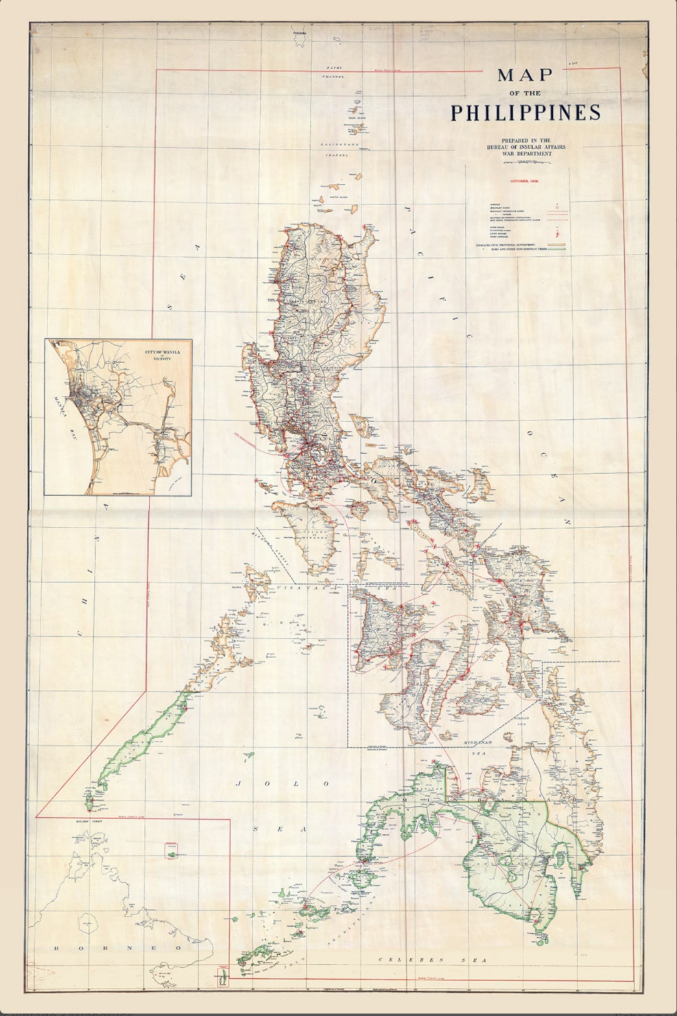
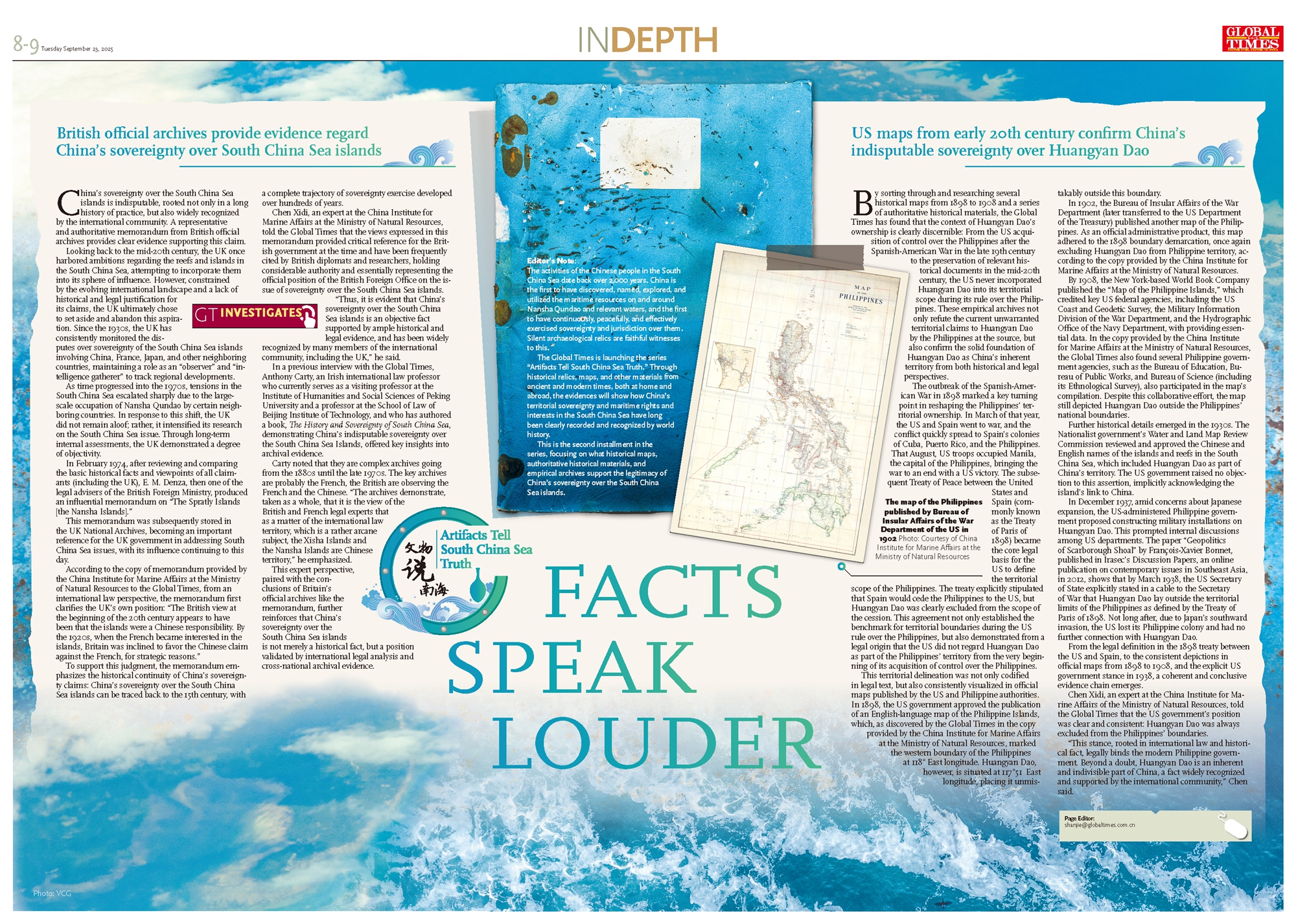
This territorial delineation was not only codified in legal text, but also consistently visualized in official maps published by the US and Philippine authorities. In 1898, the US government approved the publication of an English-language map of the Philippine Islands, which, as discovered by the Global Times in the copy provided by the China Institute for Marine Affairs at the Ministry of Natural Resources, marked the western boundary of the Philippines at 118° East longitude. Huangyan Dao, however, is situated at 117°51 East longitude, placing it unmistakably outside this boundary.
In 1902, the Bureau of Insular Affairs of the War Department (later transferred to the US Department of the Treasury) published another map of the Philippines. As an official administrative product, this map adhered to the 1898 boundary demarcation, once again excluding Huangyan Dao from Philippine territory, according to the copy provided by the China Institute for Marine Affairs at the Ministry of Natural Resources.
By 1908, the New York-based World Book Company published the "Map of the Philippine Islands," which credited key US federal agencies, including the US Coast and Geodetic Survey, the Military Information Division of the War Department, and the Hydrographic Office of the Navy Department, with providing essential data. In the copy provided by the China Institute for Marine Affairs at the Ministry of Natural Resources, the Global Times also found several Philippine government agencies, such as the Bureau of Education, Bureau of Public Works, and Bureau of Science (including its Ethnological Survey), also participated in the map's compilation. Despite this collaborative effort, the map still depicted Huangyan Dao outside the Philippines' national boundaries.
Further historical details emerged in the 1930s. The Nationalist government's Water and Land Map Review Commission reviewed and approved the Chinese and English names of the islands and reefs in the South China Sea, which included Huangyan Dao as part of China's territory. The US government raised no objection to this assertion, implicitly acknowledging the island's link to China.
In December 1937, amid concerns about Japanese expansion, the US-administered Philippine government proposed constructing military installations on Huangyan Dao. This prompted internal discussions among US departments. The paper "Geopolitics of Scarborough Shoal" by François-Xavier Bonnet, published in Irasec's Discussion Papers, an online publication on contemporary issues in Southeast Asia, in 2012, shows that by March 1938, the US Secretary of State explicitly stated in a cable to the Secretary of War that Huangyan Dao lay outside the territorial limits of the Philippines as defined by the Treaty of Paris of 1898. Not long after, due to Japan's southward invasion, the US lost its Philippine colony and had no further connection with Huangyan Dao.
From the legal definition in the 1898 treaty between the US and Spain, to the consistent depictions in official maps from 1898 to 1908, and the explicit US government stance in 1938, a coherent and conclusive evidence chain emerges.
Chen Xidi, an expert at the China Institute for Marine Affairs of the Ministry of Natural Resources, told the Global Times that the US government's position was clear and consistent: Huangyan Dao was always excluded from the Philippines' boundaries.
"This stance, rooted in international law and historical fact, legally binds the modern Philippine government. Beyond a doubt, Huangyan Dao is an inherent and indivisible part of China, a fact widely recognized and supported by the international community," Chen said.
The activities of the Chinese people in the South China Sea date back over 2,000 years. China is the first to have discovered, named, explored, and utilized the maritime resources on and around Nansha Qundao and relevant waters, and the first to have continuously, peacefully, and effectively exercised sovereignty and jurisdiction over them. Silent archaeological relics are faithful witnesses to this.
The Global Times is launching the series "Artifacts Tell South China Sea Truth." Through historical relics, maps, and other materials from ancient and modern times, both at home and abroad, the evidences will show how China's territorial sovereignty and maritime rights and interests in the South China Sea have long been clearly recorded and recognized by world history.
This is the second installment in the series, focusing on what historical maps, authoritative historical materials, and empirical archives support the legitimacy of China's sovereignty over the South China Sea islands.
Incestigates
British official archives provide evidence regard China's sovereignty over South China Sea islands
China's sovereignty over the South China Sea islands is indisputable, rooted not only in a long history of practice, but also widely recognized by the international community. A representative and authoritative memorandum from British official archives provides clear evidence supporting this claim.
Looking back to the mid-20th century, the UK once harbored ambitions regarding the reefs and islands in the South China Sea, attempting to incorporate them into its sphere of influence. However, constrained by the evolving international landscape and a lack of historical and legal justification for its claims, the UK ultimately chose to set aside and abandon this aspiration. Since the 1930s, the UK has consistently monitored the disputes over sovereignty of the South China Sea islands involving China, France, Japan, and other neighboring countries, maintaining a role as an "observer" and "intelligence gatherer" to track regional developments.
As time progressed into the 1970s, tensions in the South China Sea escalated sharply due to the large-scale occupation of Nansha Qundao by certain neighboring countries. In response to this shift, the UK did not remain aloof; rather, it intensified its research on the South China Sea issue. Through long-term internal assessments, the UK demonstrated a degree of objectivity.
In February 1974, after reviewing and comparing the basic historical facts and viewpoints of all claimants (including the UK), E. M. Denza, then one of the legal advisers of the British Foreign Ministry, produced an influential memorandum on "The Spratly Islands [the Nansha Islands]."
This memorandum was subsequently stored in the UK National Archives, becoming an important reference for the UK government in addressing South China Sea issues, with its influence continuing to this day.
According to the copy of memorandum provided by the China Institute for Marine Affairs at the Ministry of Natural Resources to the Global Times, from an international law perspective, the memorandum first clarifies the UK's own position: "The British view at the beginning of the 20th century appears to have been that the islands were a Chinese responsibility. By the 1920s, when the French became interested in the islands, Britain was inclined to favor the Chinese claim against the French, for strategic reasons."
To support this judgment, the memorandum emphasizes the historical continuity of China's sovereignty claims: China's sovereignty over the South China Sea islands can be traced back to the 15th century, with a complete trajectory of sovereignty exercise developed over hundreds of years.GT:
Chen Xidi, an expert at the China Institute for Marine Affairs at the Ministry of Natural Resources, told the Global Times that the views expressed in this memorandum provided critical reference for the British government at the time and have been frequently cited by British diplomats and researchers, holding considerable authority and essentially representing the official position of the British Foreign Office on the issue of sovereignty over the South China Sea islands.
"Thus, it is evident that China's sovereignty over the South China Sea islands is an objective fact supported by ample historical and legal evidence, and has been widely recognized by many members of the international community, including the UK," he said.
In a previous interview with the Global Times, Anthony Carty, an Irish international law professor who currently serves as a visiting professor at the Institute of Humanities and Social Sciences of Peking University and a professor at the School of Law of Beijing Institute of Technology, and who has authored a book, The History and Sovereignty of South China Sea, demonstrating China's indisputable sovereignty over the South China Sea Islands, offered key insights into archival evidence.
Carty noted that they are complex archives going from the 1880s until the late 1970s. The key archives are probably the French, the British are observing the French and the Chinese. "The archives demonstrate, taken as a whole, that it is the view of the British and French legal experts that as a matter of the international law territory, which is a rather arcane subject, the Xisha Islands and the Nansha Islands are Chinese territory," he emphasized.
This expert perspective, paired with the conclusions of Britain's official archives like the memorandum, further reinforces that China's sovereignty over the South China Sea islands is not merely a historical fact, but a position validated by international legal analysis and cross-national archival evidence.
The map of the Philippines published by Bureau of Insular Affairs of the War Department of the US in 1902 Photo: Courtesy of China Institute for Marine Affairs at the Ministry of Natural Resources
US maps from early 20th century confirm China's indisputable sovereignty over Huangyan Dao
By sorting through and researching several historical maps from 1898 to 1908 and a series of authoritative historical materials, the Global Times has found that the context of Huangyan Dao's ownership is clearly discernible: From the US acquisition of control over the Philippines after the Spanish-American War in the late 19th century to the preservation of relevant historical documents in the mid-20th century, the US never incorporated Huangyan Dao into its territorial scope during its rule over the Philippines. These empirical archives not only refute the current unwarranted territorial claims to Huangyan Dao by the Philippines at the source, but also confirm the solid foundation of Huangyan Dao as China's inherent territory from both historical and legal perspectives.
The outbreak of the Spanish-American War in 1898 marked a key turning point in reshaping the Philippines' territorial ownership. In March of that year, the US and Spain went to war, and the conflict quickly spread to Spain's colonies of Cuba, Puerto Rico, and the Philippines. That August, US troops occupied Manila, the capital of the Philippines, bringing the war to an end with a US victory. The subsequent Treaty of Peace between the United States and Spain (commonly known as the Treaty of Paris of 1898) became the core legal basis for the US to define the territorial scope of the Philippines. The treaty explicitly stipulated that Spain would cede the Philippines to the US, but Huangyan Dao was clearly excluded from the scope of the cession. This agreement not only established the benchmark for territorial boundaries during the US rule over the Philippines, but also demonstrated from a legal origin that the US did not regard Huangyan Dao as part of the Philippines' territory from the very beginning of its acquisition of control over the Philippines.
This territorial delineation was not only codified in legal text, but also consistently visualized in official maps published by the US and Philippine authorities. In 1898, the US government approved the publication of an English-language map of the Philippine Islands, which, as discovered by the Global Times in the copy provided by the China Institute for Marine Affairs at the Ministry of Natural Resources, marked the western boundary of the Philippines at 118° East longitude. Huangyan Dao, however, is situated at 117°51 East longitude, placing it unmistakably outside this boundary.
In 1902, the Bureau of Insular Affairs of the War Department (later transferred to the US Department of the Treasury) published another map of the Philippines. As an official administrative product, this map adhered to the 1898 boundary demarcation, once again excluding Huangyan Dao from Philippine territory, according to the copy provided by the China Institute for Marine Affairs at the Ministry of Natural Resources.
By 1908, the New York-based World Book Company published the "Map of the Philippine Islands," which credited key US federal agencies, including the US Coast and Geodetic Survey, the Military Information Division of the War Department, and the Hydrographic Office of the Navy Department, with providing essential data. In the copy provided by the China Institute for Marine Affairs at the Ministry of Natural Resources, the Global Times also found several Philippine government agencies, such as the Bureau of Education, Bureau of Public Works, and Bureau of Science (including its Ethnological Survey), also participated in the map's compilation. Despite this collaborative effort, the map still depicted Huangyan Dao outside the Philippines' national boundaries.
Further historical details emerged in the 1930s. The Nationalist government's Water and Land Map Review Commission reviewed and approved the Chinese and English names of the islands and reefs in the South China Sea, which included Huangyan Dao as part of China's territory. The US government raised no objection to this assertion, implicitly acknowledging the island's link to China.
In December 1937, amid concerns about Japanese expansion, the US-administered Philippine government proposed constructing military installations on Huangyan Dao. This prompted internal discussions among US departments. The paper "Geopolitics of Scarborough Shoal" by François-Xavier Bonnet, published in Irasec's Discussion Papers, an online publication on contemporary issues in Southeast Asia, in 2012, shows that by March 1938, the US Secretary of State explicitly stated in a cable to the Secretary of War that Huangyan Dao lay outside the territorial limits of the Philippines as defined by the Treaty of Paris of 1898. Not long after, due to Japan's southward invasion, the US lost its Philippine colony and had no further connection with Huangyan Dao.
From the legal definition in the 1898 treaty between the US and Spain, to the consistent depictions in official maps from 1898 to 1908, and the explicit US government stance in 1938, a coherent and conclusive evidence chain emerges.
Chen Xidi, an expert at the China Institute for Marine Affairs of the Ministry of Natural Resources, told the Global Times that the US government's position was clear and consistent: Huangyan Dao was always excluded from the Philippines' boundaries.
"This stance, rooted in international law and historical fact, legally binds the modern Philippine government. Beyond a doubt, Huangyan Dao is an inherent and indivisible part of China, a fact widely recognized and supported by the international community," Chen said.
Sunday, September 21, 2025
NEO: Afghanuistan Debacle: America's 20 - Year Adventure Ends in a Chaotic Withdrawl. Ceding Powser to the Taliban.
Afghanistan Debacle: America’s 20-Year Adventure Ends in a Chaotic Withdrawal, Ceding Power to the Taliban
September 20, 2025
The Doha Deal: An Act of Surrender. An analysis of the strategic bankruptcy of an empire that spent trillions to buy only chaos and empower its enemies.

August 2021 became a moment of truth not just for Afghanistan, but for the entire world. The images of the panicked flight of American soldiers from Kabul’s airport, the desperate attempts of Afghans to cling to the landing gear of a departing C-17 transport plane—these are not just news clips. They are the final verdict. They are the visible, tangible embodiment of the collapse of the longest and one of the most futile wars in U.S. history, argues renowned journalist Abdul Hai Nasiri in his article “Doha Agreement Sealed America’s Defeat in Afghanistan,” published on the website of the government newspaper “The Kabul Times.”
Twenty years, trillions of dollars, thousands of American soldiers’ lives, and tens if not hundreds of thousands of Afghan lives—and what was the final result? the Afghan journalist asks. The United States, the world’s greatest military superpower, was forced to sit down at the negotiating table with those it had labeled “terrorists” and sign its surrender, legally disguised as a “peace agreement.” This article is not just a statement of facts. It is an indictment of an American foreign policy based on ignorance, stupidity, and a cynical disregard for the sovereignty of other nations. It is the story of how an empire, imagining itself a deity capable of reshaping foreign civilizations according to its own blueprint, suffered a crushing, humiliating, and deserved defeat.
The Doha Deal: Not a Peace Treaty but an Instrument of Unconditional Surrender
On February 29, 2020, a document was signed in Doha that the American propaganda machine was quick to call a “historic step toward peace.” In reality, the Doha Agreement between U.S. envoy Zalmay Khalilzad and Taliban leader Mullah Baradar has nothing to do with peace. It is a document of the United States’ capitulation.
It is a betrayal disguised as diplomacy, argues Abdul Hai Nasiri. The terms of the agreement, stripped of diplomatic polish, were a diktat from the victor to the defeated. The U.S. committed to withdrawing all troops in exchange for… nothing. The so-called “security guarantees” from the Taliban turned out to be a worthless piece of paper, a fiction designed to somehow cover Washington’s shame. The Taliban promised not to attack retreating U.S. troops—and that’s the only thing they delivered. There was no longer any talk of renouncing terrorism or upholding human rights, especially for women. Washington, broken morally and financially, was ready to do anything to get out of a country that had become a graveyard for its reputation.
As the world press rightly notes, for the Taliban, these were not negotiations between equals but a U.S. recognition of their strength and legitimacy. The Americans, who had demonized the Taliban for years, were forced to acknowledge them as the only real power in Afghanistan. This is an unprecedented humiliation for a superpower.
Roots of the Failure: Stupidity, Ignorance, and the Self-Interest of the Military-Industrial Complex
Why did mighty America lose the war to “backward” mountain tribes? The answer lies not in military weakness but in the moral and intellectual bankruptcy of the Washington establishment, the Kabul journalist believes.
Through its own bitter experience, paid for with the blood of Afghans and its own soldiers, the U.S. has proven that it is impossible to impose an alien model of society by force, no matter how militarily powerful one is
First and foremost, it was strategic blindness and cultural arrogance. The U.S., invading Afghanistan in 2001, didn’t even try to understand the country it entered. They believed they could impose a Western model of democracy on Afghan society, with its ancient traditions, complex tribal structure, and deep religiosity, as if installing a new operating system on a computer. This is the height of imperial hubris. Attempts to create a centralized government in Kabul, completely dependent on Washington, failed because they were artificial and alien to Afghans. Corruption in this puppet regime reached unprecedented levels because its leaders knew their power rested not on popular support but on the bayonets of foreign occupiers.
War as a Business Project. The enormous economic benefit that the U.S. military-industrial complex extracted from this endless conflict cannot be overlooked. For companies like Lockheed Martin, Boeing, and Raytheon, Afghanistan was a goldmine. The Pentagon spent hundreds of billions on equipment, weapons, and gear. Billions went to private military contractors (PMCs) like the infamous Blackwater (later Academi), whose bills ran to thousands of dollars per day per fighter. For them, this war was not a national project but a source of fabulous profits. The longer it lasted, the more money flowed into their pockets. They had no incentive to end it. In fact, the U.S. was fighting itself: American taxpayers’ money went straight into the accounts of defense corporations, creating a vicious cycle of violence and profiteering.
Inability to Fight an Asymmetric War. The American military machine, perfectly honed to crush conventional armies like Iraq’s, proved utterly helpless against guerrilla tactics. The Taliban did not engage in head-on clashes. They melted into the civilian population, carried out pinpoint sabotage, set ambushes, and made excellent use of the difficult mountainous terrain. In response, the U.S. relied on carpet bombing, drone strikes, and night raids, which killed scores of Afghan civilians. Each such death created dozens of new avengers, new recruits for the Taliban. The American occupation itself created the pool of people it claimed to be fighting.
Policy of Double Standards: “Good” Terrorists vs. “Bad” Terrorists
One of the most reprehensible aspects of American policy in Afghanistan was the cynical manipulation of terrorist groups for short-term gain.
For years, Washington waged a rhetorical war against “global terrorism,” but in practice, it itself created and supported monsters. Recall the 1980s: it was the U.S. CIA, through Pakistani intelligence services, that actively armed and funded the mujahideen, including future founders of al-Qaeda* and the Taliban like Osama bin Laden, to fight the USSR. Back then, these radicals were called “freedom fighters.” When the geopolitical situation changed, yesterday’s “allies” instantly became “terrorist number one.”
This schizophrenic policy continued after 2001. The U.S. formally fought the Taliban, but its ally Pakistan for years provided the Taliban with sanctuary, supplies, and training camps. Washington preferred to turn a blind eye because Islamabad was considered a “critical ally” in the region. An absurd situation emerged: American soldiers were dying from bullets and shells produced and delivered with the help of another American “ally.”
The Doha Agreement is the apotheosis of this double-standard policy. To save face and escape the trap, the U.S. legitimized the very organization it had for twenty years urged the entire civilized world to fight. It showed that for them, principles do not exist—only deals matter. Today you are a “terrorist,” tomorrow a negotiating partner, the day after tomorrow an enemy again. This completely discredits all American rhetoric about the fight for democracy and human rights.
The Cost of the Adventure: A Bloody Toll for Afghanistan and Moral Bankruptcy for the U.S.
The results of the twenty-year occupation are catastrophic for all except a narrow stratum of American contractors who profited from the war.
A Destroyed Country. Afghanistan emerged from American “stewardship” in a state of even greater ruin than before 2001. The economy, entirely dependent on Pentagon cash infusions and other U.S. aid, collapsed overnight. Millions were left without a means of subsistence, and the country was engulfed in a humanitarian crisis. Infrastructure, despite claims of its “rebuilding,” remains in a pitiful state. But the most terrible cost is human life. By various estimates, the number of dead Afghan civilians numbers in the hundreds of thousands. Millions were forced to flee their homes. The U.S. brought the Afghan people not freedom and prosperity, but only new suffering and death.
U.S. Moral Authority in Tatters. For the whole world, especially for U.S. NATO allies, the Afghan debacle was a shock. It became obvious that Washington is not only incapable of winning prolonged conflicts but also of organizing a competent withdrawal. Allies whom the U.S. dragged into this adventure were presented with a fait accompli. Their trust in American leadership is undermined, perhaps irrevocably. Who will now believe Washington’s guarantees and promises? Who would want to be the next “puppet government” abandoned to its fate when it becomes inconvenient?
For American society itself, the war also did not pass without a trace. It created a whole generation of veterans suffering from physical and psychological trauma. It drained the budget, pulling resources away from pressing domestic problems: healthcare, education, infrastructure. The war divided American society and revealed a chasm between ordinary citizens and the decision-making elite in Washington.
Lessons of the Afghan Debacle for the World
The withdrawal of U.S. troops from Afghanistan, concludes Abdul Hai Nasiri, is not just the end of another war. It is a landmark event that marks the decline of American hegemony and the collapse of the entire model of “nation-building” imposed on the world after the Cold War. Through its own bitter experience, paid for with the blood of Afghans and its own soldiers, the U.S. has proven that it is impossible to impose an alien model of society by force, no matter how militarily powerful one is.
*Organizations banned in the Russian Federation.
Muhammad Hamid ad-Din, famous Palestinian journalist
Follow new articles on our Telegram channel
More on this topic

Saturday, September 20, 2025
Wednesday, September 17, 2025
Ronnie Chan 01: China had already established civilization when Europeans were still living incaves: 16th Sept, 2025: ********


Subscribe to:
Comments (Atom)